Executive Summary
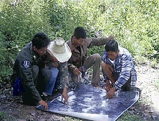
A transect walk is a systematic walk along a defined path (transect) across the community/project area together with the local people to explore the water and sanitation conditions by observing, asking, listening, looking and producing a transect diagram. The transect walk is normally conducted during the initial phase of the fieldwork. It is best to walk a route, which will cover the greatest diversity in terms of water resources and sanitation infrastructure. The transect walk is conducted by the research team and community members. The information collected during the walk is used to draw a diagram or map based on which discussions are held amongst the participants.
What Is a Transect Walk?
(Adapted from INTERCOOPERATION 2005; ZEEUW and WILBERS 2004)
Transect walks are promenades through the project area conducted by researchers and participants to gain an understanding of the water resources, wastewater flows and sanitation facilities of a location, their diversity and associated problems, and to assess opportunities. Regarding sanitation and water management, parameters usually include fresh water sources, water purification and distribution, water use, wastewater collection and treatment and reuse as well as analysing the local nutrient cycle (see also understand your system). If a transect walk is conducted at the beginning, middle and end of the project period it can also be used for monitoring and evaluating changes along the particular route. Furthermore, transect walks can be used to compare reactions/discussions of different types of stakeholders (see stakeholder analysis starting by stakeholder identification factsheet), such as government officials, NGO team members, the local community, etc. In addition, these walks can provide a good cross-section of information that can be used for specific purposes of verification and appraisal.
During the walk, participants discuss everything encountered or noticed which could be of relevance to water management, sanitation and agriculture. The team members facilitate these exchanges by asking questions and making observations. They also record the discussions/take notes. Furthermore, the team members can informally interview any people met during the walk to get their views on the resources and land use visible at that spot.
The transect walk is normally done during the initial phase of the fieldwork. It is adequate to choose a route, which will cover the greatest diversity regarding water, sanitation and agricultural issues. The transect walk is conducted by the research team and representatives of the most important stakeholder groups. The promenade may take a couple of hours. If the walk is likely to take longer, the transect walk may be divided into segments, each assigned to a small team.
Why a Transect Walk?
(Adapted from WORLD BANK n.y.; ZEEUW and WILBERS 2004)
A transect walk introduces the team to the community, its inhabitants and their area and is a way to collect information about whether the water and wastewater resources are sustainable managed in a locality. The walk can also be used to identify problems and opportunities e.g. regarding resource use and access to resources in the various parts of visited area. Transect walks can have the following outcomes:
- identifying and explaining the cause and effect relationships among water sources, water purification and distribution as well as the use, collection, treatment and reuse of (waste)water and nutrients (see also understand your system)
- identifying major problems and possibilities perceived by different groups of local analysts in relation to features or areas along the transect
- learning about local technology and practices
- contributing as a tool for site selection
- triangulating data collected through other tools
How to Conduct a Transect Walk?
(Adapted from INTERCOOPERATION 2005)
- Identify a group of key informants. Ideally, the participants should include all important stakeholder groups they should all be willing to walk some distance, and share their observations.
- Discuss with the participants the purpose of the walk, and decide on the path that should be taken to cover the full geographical variation in the area. The ‘path’ may not be a path at all – ideally, as a true cross-section, it should be a straight line. However, if the path roughly corresponds to at least part of the cross-section, it may be easier to use it. Maps or aerial photographs (e.g. from Google Earth) may be of use, if available, but are certainly not essential. For monitoring and evaluation purposes, it is important that the route of the transect walk can be easily found again and again, possibly after substantial periods of time.
- Decide with the key informants what parameters should be used for recording observations. Local definitions of these parameters should be explored. It is best to limit the parameters covered to five or six at maximum; trying to collect too much information may only result in confusion.
- In general, the easiest and most stimulating part of transect walks is the walk itself and the discussions that arise during it, with the local people as experts. Documenting it afterwards can be more difficult. It helps to clearly decide specific observation points along the transect walk at which everyone stops to record all parameters.
What Is Needed?
(Adapted from INTERCOOPERATION 2005; WORLD BANK n.y.)
The transect walk may take two to three hours. After the walk you produce and analyse a transect diagram, and ensure that a full discussion occurs with local analysts. In large areas where a transect walk would take longer to produce (for example, four or more hours), it might be sensible to divide it up into smaller transect segments that can be combined later.
The participants are groups of women and men (see also gender issues), who are willing to walk and talk amongst themselves and the facilitators through a transect walk.
With the participants, decide a route to be followed. Try to choose a route with varied environmental and topographical features.
Materials needed for the walk itself:
- Notebook and pen
- Appropriate clothing and footwear for the area and time of year
- Maps or aerial photographs if available, e.g. from Google Earth
- If the details of the transect are to be incorporated into a GIS, (computerised Geographical Information System), you may take along a GPS (Global Positioning System) device. However, this is not necessary in most cases
- You could also take along a camera to record certain things, or a voice recorder if you wish to interview somebody
For the subsequent write-up:
- Large sheets of paper (see also managing flipcharts)
- Coloured pens
- Small coloured cards for marking particular items of interest
How to Continue?
(Adapted from FAO 2003; WORLD BANK n.y.)
The information collected during the transect walk is used to draw a diagram or map and provides a basis for discussion amongst participants. It might be useful to have a list of key questions to guide a discussion about the information gathered during the transect walk. Key questions might include the following examples (note: the following links will lead you to the sub-steps of the “Understand your System” section of this toolbox – there, you will find more detailed questions for each of these areas):
- Outline: Where do different population sub-groups live? Are they segregated or mixed? Do the poorest households live in certain areas?
- Water sources: Where does the water come from? Is there enough water for every use and what is the quality?
- Water purification and distribution: Is the water purified and how does the water come to the different users?
- Water use: Who are the main water users and how much water is used? For what purpose?
- Wastewater collection: Where does the used water go? Is it collected and treated?
- Wastewater treated: Is industrial/domestic/agricultural wastewater treated? In a centralised or individual manner? Up to which level?
- Nutrients / Recharge and reuse: Are water and nutrients being recycled or just discharged?
- What happens with organic waste?
- What constraints or problems are in the different areas regarding water, wastewater and sanitation?
- What possibilities or opportunities are in the different areas?
- How will a proposed policy change or implementation affect the features and characteristics of different areas?
If local analysts have sufficient time, it might be useful to ask them to draw a series of diagrams to illustrate changes over time.
If there are several different groups, ask each group to present its diagram to the others for their reactions and comments. Are there serious disagreements? If so, note these and if a consensus is or is not reached.
Subscribe here to the new Sanitation and Water Entrepreneurship Pact (SWEP) newsletter. SWEP is a network of organizations joining hands to help entrepreneurs design and develop lasting water and sanitation businesses.
The transect walk introduces the research team to the community and its inhabitants and is a way to collect (spatial) information about water resources, wastewater flows and sanitation facilities of a village. The walk can also be used to identify problems and opportunities e.g. regarding resource use and access to resources in the various parts of the transect visited. Through the direct field observation and exchange of information local community members learn to identify water and sanitation problems which will gradually lead to the identification their causes and possible solutions.
Facilitator’s reference material. Annex
Participatory Monitoring And Evaluation. Field Experiences
This document contains and describes the application of various participatory tools such as transect walks, well-being ranking and matrix ranking.
INTERCOOPERATION (2005): Participatory Monitoring And Evaluation. Field Experiences. Hyderabad: Intercooperation URL [Accessed: 29.06.2019]Tool name: Transect Walk
This paper describes the transect walk as a method and contains some visual examples of transect diagrams and maps.
WORLD BANK (n.y): Tool name: Transect Walk. Washington, DC: World Bank URL [Accessed: 29.06.2019]Methodology for transect walk
This document gives a good overview of the transect walk method. It explains exactly how to conduct a transect walk and how to continue after the walk.
WORLD BANK (n.y): Methodology for transect walk. Washington, DC: World Bank. [Accessed: 22.04.2012] PDFPRA Tools For Studying Urban Agriculture And Gender
Participatory Monitoring And Evaluation. Field Experiences
This document contains and describes the application of various participatory tools such as transect walks, well-being ranking and matrix ranking.
INTERCOOPERATION (2005): Participatory Monitoring And Evaluation. Field Experiences. Hyderabad: Intercooperation URL [Accessed: 29.06.2019]Methodology for transect walk
This document gives a good overview of the transect walk method. It explains exactly how to conduct a transect walk and how to continue after the walk.
WORLD BANK (n.y): Methodology for transect walk. Washington, DC: World Bank. [Accessed: 22.04.2012] PDFTool name: Transect Walk
This paper describes the transect walk as a method and contains some visual examples of transect diagrams and maps.
WORLD BANK (n.y): Tool name: Transect Walk. Washington, DC: World Bank URL [Accessed: 29.06.2019]A transect walk undertaken in Itereleng informal settlement to observe community vulnerability
This document is an example of a transect walk conducted in Tshwane in order to analyse the community vulnerability of informal settlements.
STADEN, D. van ROGERS, E. MAKAUDI, I. WINKLER, J. WHITE, J. KANGALE, M. RUDMAN, N. NKOSI, S. DREYER, T.R. COETZER, T. (2006): A transect walk undertaken in Itereleng informal settlement to observe community vulnerability. Pretoria: City of Tshwane Metropolitan URL [Accessed: 29.06.2019]